No Middle Middle today. No, I was heading to the Ohanepecosh. The Ohanepecosh, pronounced "o-han-ee-pe-cosh", cascades down off the east side of Mt Rainier. Even if you are simply looking for a good reason to get out of the city, or just go for a hike, this area is stunning and very easy to drive to. About 3 hours from Seattle, it is well worth the windshield time especially when partaking in a full weekend of exploration in such a fine fine place as this. Ohanepecosh is a Taidnapam Indian word that is thought to mean "Standing on the Edge".
I hit the road early, leaving town around 7 Sat morning. I met Kris and Kenny at Spiffy's for breakfast. A neat little joint right off I-5 on highway 12 east. We were on the way to rendevous in the 'wood. Two other friends from Oregon had come up the night before. The 'Wood is 70 miles east of I-5. A long way in means most certainly the darkness is looming. Unfortunately for my two Oregon friends, the darkness started outside of Packwood (the 'wood) the night before. Two elk had jumped out in front of them. One got lucky, but the second could not be avoided. The elk died along with the idea of camping in the woods 5 miles away. :(:(:( Michelle and Dave were chillin' next to the road and Michelle's crumpled Subie. They figured that there was no use crying over spilled milk. And like any worthy paddler who knows of the riches to be found in the waterfall-studded wonderland known as Mt Rainier Nat Park, they rallied up with me and we all headed for the put in.
It was Sat and I had been up the Tue before just for the day. That was a long day! 350 miles round trip from Seattle. Today was a nice low flow. Michelle, Dave, and Kenny had not been on this run before. At this flow it was more IV than V, but you still had to pay attention. There were places you didn't want to get pushed. The Ohanepecosh is one of the most beautiful river canyons I have been to. While not as isolating as, say, the box canyon of the Carbon, it still carries a commitment factor, not to mention some of the burly drops that lay upstream buried in logjams. We only do the second half of the classic run now. In Nov of 2006 there was a flood of epic proportion. The biggest many rivers had gotten in recorded history. Mt Rainier National Park received 18 inches of rain in a 36 hour period. I did not kayak that day.
Check out what the National Park Service found... http://www.nps.gov/mora/parknews/upload/floodPP.pdf
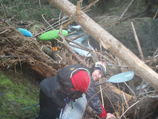
Rivers entirely changed course. Miles of road were washed away, landslides, entire mountainsides of forest were swept away. Epic. Well some of those piles of trees are still in the park, they've simply been relocated into the top half of the run. There are still drops to run up there, but putting in at Secret Camp leaves most of the wood behind. And you will immediately be rewarded with crystal clear waters in a spectacular bedrock canyon. If you have time, take a look at the impressive series of drops just upstream. Much has changed, but this stretch is in pretty good shape. There is a log blocking the bottom left slot at the put in. Scout everything you can see at the put in so you don't miss it. From the water a log can be seen coming in from the left wall, but it's hard to tell if it goes all the way across the slot.
One of the first drops is Log Boof. And as the name implies there's a log AND a BOOF! Make sure your angle is just right otherwise you flip backwards off the log and fall five feet onto your head. Today was my day to run that sucker backwards! Takeoff never goes as expected when taking this line. Exciting nonetheless! I couldn't roll up because the log was less than 2 feet above the water. There was just no room. After draining the boat and pulling it out of the water I had to go up and run it again. No problems second time. Pay attention, dude. Drop after drop, all stacked up throughout the canyon. Unbelievably scenic, I can't remember all the names of the drops. Some are really tight ledges barely wide enough for a boat. We portaged one because of wood that's kind of hard to see if you're boat scouting your way down. It would probably be impossible to see from above with med-high flows. If you haven't done it before you'll probably want to look at several drops and may walk a few.
Then we got to Elbow Room. Elbow Room is in a deeper part of the canyon and loses about 35 feet of gradient over 50 yards or so. Several moves are linked to finish this V+ drop in tact. Basically it kinda starts out with "GET LEFT, HURRY!!" Then..."ok gET LEFT!!" Next...c'mon, left!! stay left through here... stay left.. ok, your done. I've only seen this drop at low flows and it doesn't look friendly. Neither does the portage. One way or another you're gonna work. The portage takes awhile. I like to go up and around, the other portage route is a little sketch and puts you on a one foot wide ledge 60 feet above the worst part of the rapid. Rope boats across, then slide on your belly. No easy way to get it done. And it is a little scary. The crux in this drop is staying left of a giant slab of rock that has fallen from the right wall into the smack-dab-middle of the rapid. Most of the water goes to the right of a dividing rock, just upstream of the slab. The danger is all of the water going right pours through, and under the slab rock. I know of one person who ran right. They swam and lived, but it was not a fun moment. Be careful here.
Immediately downstream of Elbow Room is a small little drop made by a giant riverwide flat bedrock shelf. At low flows run it about anywhere. Then comes the waterfall. The waterfall has some pucker factor. There is a big juicy aerated hole five feet above. It's really one huge pothole in the bedrock before the falls, but you have to go around it to hit the falls. This is a bad hole to get stuck in. Immediately downstream is the biggest drop on the run, save Elbow Room. This class V drop is called Petrified. Petrified is a multi-tiered twisting ledge drop. The entry is tight and fast, twisting to the left, leading to the lip of the main ledge. I like to boof out center with speed, but you can go left or right as well. Just don't get stuck in that hole!!! The hole at the bottom of this ledge is basically a GIANT pothole that helps keep this thing backed up. It's kind of cool coming off the lip and seeing all the water moving back upstream at you. Upon landing, please carve hard left off the next 4 foot ledge as the drop continues to twist left. Then you just have to go left off the final ledge, missing the sievey rock pile at the bottom where the main flow goes. You'll know it by the log sticking out of it. Someone should be ready with a rope at Petrified and the hole above the waterfall is not a bad idea either. I saw someone swim at the main ledge in Petrified. At one point the paddle, paddler and boat were all cartwheeling side by side. Not pretty. Eddy out at the bottom to collect everyone, run the next few drops and you're done!!
One of these remaining drops has an angled piece of bedrock that you'd better hit just right. I went far left. It's just a little 3 or 4 foot boof, but there's a knob that sticks out. It looks like a good boof flake from above. The main slot is about 5 feet wide. I watched Kris and Kenny do the stern-retendo to bitch-slap/flip off the rock that makes the right side of the ledge. Wonder if Ohane has a Gorge Beast. I didn't want to find out. I was right above Kenny, and when I saw him go over, I boogied.
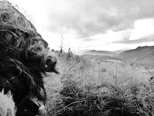
The take out is at La Wis Wis Campground. In the winter they lock the gate so you have to walk up the road about a half mile or so. A nice way to end it, I think. Earn those boofs. We finished up, drank beer, laughed, cried, then we all departed. Kenny took Michelle back to Portland so she could grab Dave's van and come back in the morning to pick everything up. Dave, Michelle's dog Cooper, and I all stayed the night at the Secret Camp. It rained. Shocker. That whole area out there is so pretty though. Somehow our gear got left out (and not hung up) all night. We decided scouting might be a warmer option for Sun.
Skate Creek, a trib of the Cowlitz, has a neat III+/IV run in the Bennett book. Downstream of this run the gradient tears down through the rock at an incredibly steep pace. I've never been on anything that steep, so I'm not sure how to gauge the gradient, but it looks much steeper than the Little White or Jefferson Creek on the O P. I'm guessing it's in the 600-800fpm neighborhood. And I think it's one of those that wants just the right amount of water. Otherwise it's a pin-fest or a freight train. The other thing is the bit of wood on here increases the pucker of this section. At least half a dozen pieces of wood should come out. A saw would help. Wouldn't need much rope if it was bucked it up. I'd sure like to see it with more water. There are some cool sequences, and some borderline stuff, too.
Leaving for the OP tomorrow night. Not sure what'll be running, but I'm gonna be out there. Hoping for Jefferson and Elkhorn Canyon. I've missed Elkhorn for months. Nasty hike in on that one, haven't missed that. Got some exploring to do. Have you heard of the Tshletshy?